What Is the Highest Point in Barry County, Michigan?
If you’re someone who enjoys seeking out hidden natural gems or checking off the high points of every county, you’ll probably want to pay a visit to a quiet little spot in Barry County, Michigan – a place called French Benchmark. It may not be a towering peak with panoramic views, but for local explorers, highpointers, and outdoor enthusiasts, it’s an intriguing destination nestled within the Barry State Game Area.
The peak of Barry County
French Benchmark is the colloquial name for the summit of Barry County, but its hill has no name. No great cliffs and panoramic views to be had here – the top of the hill is wooded and ringed with thorny scrub, likely barberry, which will make the steep ascent up a bit scratchy. While it doesn’t have the dramatic sweep, it is well compensated by tension and serenity among the thorns.
Located in the Barry State Game Area, a massive 17,000-acre piece of open land for wildlife management and outdoor recreation, French Benchmark is part of an overwhelmingly Michigan-aware landscape. Hunters, hikers, birders, and even those individuals who try to identify all the high points in a single Michigan county find themselves visiting the site.
A Little History
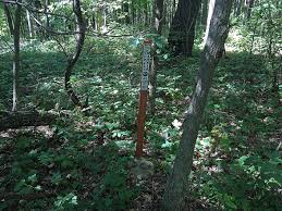
French Benchmark is so-named because it sits atop the hill above the USGS benchmark but don’t expect to find some giant honking monument or observation tower. It’s a metal plate screwed to rock. The only reason the site is slightly more interesting is that there is historical proof a fire tower once stood on the site. You can still view the concrete remains of what would have been its foundation, and even a map of Barry County designates the nearby trail as “Fire Tower Trail.” While the trail itself has disappeared nearly completely and there are no online sources, there’s enough there to fuel the fires of imagination. If it’s crumbling buildings and old ruins hidden deep in the forest that get your imagination going, then this is yours.
Getting Here Ain’t That Bad – Until the Last Stretch
Reaching the general vicinity of French Benchmark is relatively simple thanks to its central Michigan location. It lies near the western edge of Barry County, not far from the town of Middleville, and can be accessed from several major roads including US-131, M-179, M-37, and M-43. Depending on your direction of travel, you’ll either head in via Yankee Springs Road or nearby local routes.
Your perfect parking location is at the Barry State Game Area Headquarters off Yankee Springs Road. Head south for a little ways on Hart Road, which is a sandy one-lane road that’s technically more of an off-road trail than a road. Technically doable in a normal car, but it’s sandy and bumpy four-wheel drive and increased clearance are best. But if one moves slowly, even most cars can make it to the tiny parking lot half-way.
The Hike Or Rather, the Bushwhack
This is where things get a little crazy. Off of the parking lot, the climb to the summit is more bushwhack than trail. Because “Fire Tower Trail” has been so underused, there is no blazed trail to follow. Expect to fight through weeds like the obnoxious barberry that appears to be top cover. GPS is your friend here because there are no signs or even visible blazes on the trail.
If you’re hiking in shorts, take gaiters or long socks with you at least those thorns aren’t humorous. And it’s open hunting ground, so it’s a good safety precautionary measure to wear blaze orange while hunting season.
Camping and Nearby Attractions
If you’re making a trip of it, the region around French Benchmark has some excellent camping options. The Yankee Springs Recreation Area, just nearby, offers well-maintained campgrounds, scenic lakes, and miles of trails for hiking and biking.
And if you’re an endurance backpacker or thru-hiker aficionado, you’ll be happy to know that the North Country National Scenic Trail (NCT) is somewhere between 1 and 2 miles north of French Benchmark. The Chief Noonday Road trailhead along M-179 likely is the nearest road access to the trail in the vicinity.
Maps and Resources
If you’d rather organize your own trip, useful maps are the USGS Cloverdale 7.5 x 7.5 quadrangle, the Barry State Game Area map, and the North Country Trail MI-02 map (Marshall to 76th Street). Honestly, they don’t mark the hill French Benchmark on any of them — it’s a plain-in-plain-sight location.
No Red Tape, Just a Bit of Planning.
There’s no entrance fee, no permits required, and generally no barriers to visiting French Benchmark. But keep in mind, it’s within public hunting land, so understanding Michigan’s hunting seasons is a must if you’re hiking during the fall or early spring. It’s always good practice to check with the Michigan Department of Natural Resources (DNR) before heading out.
French Benchmark isn’t the state of Michigan’s top-high-profile gathering place, but it’s one of those little secrets for nature lovers who love quiet nature, back-road stops, and a little old-fashioned exploring.
No gift shops and no crowds lurking in wait, but trees, silence, a touch of mystery, and a thorn or two scattered here and there. For nature nerds, highpointers, or just someone who would like to be able to say they’ve stood at the top of Barry County, it’s a satisfying little task. Just take a GPS, long pants, and an inquiring mind.