Kansas City Weather Alert: Weekend Temperatures in Teens, Wind Chills Below Zero in Metro and Northern Areas
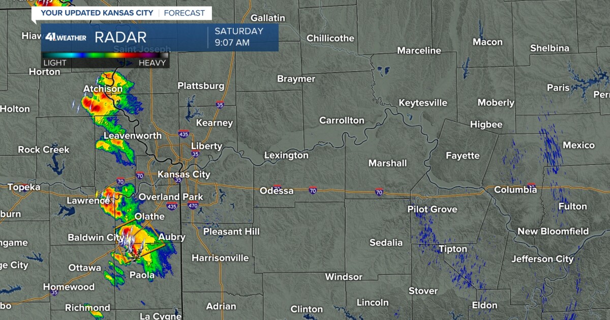
The Kansas City metro area will experience a significant cold snap this weekend following Friday’s bursts of snow. Light snow is expected to continue until around 1 a.m. Saturday, leaving a dusting of up to 0.5 inches on roads and sidewalks, with isolated higher amounts possible.
Once snow showers clear, residents will face sub-freezing temperatures and hazardous wind chills. Saturday’s First Warn highlights the dangers of the arctic air, emphasizing the need for precautions.
Forecast for Saturday: Dangerous Wind Chills
Morning lows in Kansas City will dip to 14 degrees, with wind chills near 0 degrees. Northern areas of the metro could feel as cold as 5 to 10 below zero, according to meteorologists.
A few scattered flurries are possible Saturday morning, but the day will largely be dry with partly cloudy skies. Officials recommend minimizing outdoor exposure and wearing multiple, loose layers, hats, mittens, and warm footwear.
Timeline of Events
Friday Night
-
Light snow continues until 1 a.m.
-
Roads accumulate a thin layer of snow, causing slick spots on bridges and highways.
Saturday Morning
-
Morning temperatures fall into the teens across Kansas City metro.
-
Wind chills drop near zero in central areas, and well below zero in northern suburbs.
Saturday Afternoon
-
Skies become partly cloudy; temperatures remain cold but stable.
-
Wind chill hazards decrease slightly as winds moderate.
Sunday Morning
-
Lows in single digits; wind chills between -5 and 0 degrees.
-
Sunshine gradually warms temperatures into the low 40s by the afternoon.
Sunday Night
-
Another cold front arrives, setting up a dramatic cool down into the workweek.
Monday
-
Morning lows in the teens, afternoon highs only reaching the mid-20s.
-
Winds are weaker than Saturday, so wind chills are less severe.
Tuesday and Beyond
-
Afternoon highs return to the 40s, above average for mid-January.
-
Sunshine and milder conditions round out the workweek.
Safety and First Warn Advisories
The National Weather Service (NWS) has issued a First Warn for Kansas City and surrounding areas due to extreme wind chills. The advisory covers most of the metro area, including Jackson, Clay, Platte, and Cass Counties, as well as northern suburbs.
Residents are urged to:
-
Limit time outdoors
-
Dress in layers
-
Cover exposed skin to avoid frostbite
-
Check on elderly neighbors or vulnerable populations
Local officials remind residents that even short exposure to these conditions can be dangerous.
Public Reaction
Many residents shared concerns about the arctic air over social media. Some noted that morning commutes could be hazardous on bridges and overpasses.
For those planning weekend activities, precautions are crucial. Parks, trails, and other outdoor venues remain open, but warnings about wind chill hazards are in effect. Residents are advised to postpone outdoor plans when possible.
Travel and Road Conditions
Road crews continue to treat highways and secondary roads across the metro, including I-70, I-35, I-435, and US-169.
Drivers are warned that spotty icy patches may develop, particularly on elevated surfaces and shaded areas.
Airports in Kansas City are expected to operate normally, though travelers may experience delays if weather systems produce flurries during early Saturday.
Public transit is largely operational but may experience slower service due to cold-weather precautions.
Looking Ahead: Relief on the Way
After Sunday’s coldest temperatures, milder air is expected to return Tuesday. Afternoon highs in the 40s will provide some relief to residents who have endured the single-digit wind chills over the weekend.
Forecasters note that sunshine and calm winds will accompany the warmer air, improving conditions for outdoor activities and commuting. However, residents should remain prepared for sudden changes, as arctic fronts can push temperatures down quickly.
NEWS SUMMARY TABLE
| Key Detail | Information |
|---|---|
| Event | Arctic blast with sub-zero wind chills |
| Location | Kansas City metro (Jackson, Clay, Platte, Cass Counties) |
| Date | Saturday–Sunday, Jan. 16–17 |
| Who Is Affected | Residents, commuters, outdoor workers, vulnerable populations |
| Current Status | Wind chills in single digits; First Warn in effect; light snow Friday night |
| What Readers Should Know | Dangerous wind chills Saturday and Sunday mornings; brief warm-up Sunday afternoon; safety precautions advised |
FAQ SECTION
1. What are the expected wind chills in Kansas City this weekend?
Wind chills could dip below zero Saturday morning, with northern areas experiencing -5 to -10 degrees.
2. Will there be snow accumulation?
Yes, light snow may leave a dusting of 0.5 inches Friday night, with isolated higher amounts possible.
3. How should I dress for the weekend?
Wear multiple loose layers, hats, mittens, scarves, and insulated shoes to protect against extreme wind chills.
4. Which counties are most affected?
Jackson, Clay, Platte, and Cass Counties, including northern suburbs, are most at risk for sub-zero wind chills.
5. Are outdoor activities safe?
Short periods outdoors are possible with proper protection, but prolonged exposure is hazardous.
6. When will temperatures return to normal?
Milder air is expected Tuesday, with highs in the 40s and calmer winds.
7. Are roads and airports safe to travel?
Highways are being treated, and airports are operating normally, though flurries may cause delays.
CONCLUSION
Kansas City is experiencing a significant arctic blast this weekend, with wind chills in the single digits posing serious hazards. Residents and commuters are urged to take precautions, limit outdoor exposure, and bundle up. While Sunday offers brief afternoon relief, the workweek begins with continued cold before a return to milder, sunnier conditions Tuesday. Monitoring official weather alerts is recommended for safety and travel planning.