Arctic Blast Targets 20+ Kansas City Metro Counties: Wind Chills Near Zero and Weekend Snow Threaten Hazardous Conditions
A surge of arctic air is about to settle over the Kansas City metropolitan region, bringing the coldest temperatures of the season and wind chills near or below zero. The National Weather Service and local meteorologists warn that the combination of light snow, strong winds, and sub-freezing temperatures will create hazardous conditions across the metro and surrounding counties.
The shift from Friday’s snow to a powerful cold snap beginning late Friday night will impact more than 20 counties across Missouri and Kansas, including Jackson, Clay, Platte, Cass, Johnson, Wyandotte, and Leavenworth counties.
A First Warn alert remains in effect throughout the weekend due to the severe wind chill risk. Forecasters say the cold will be dangerous at times, particularly during early morning hours when temperatures fall into the teens and wind chills hover near zero or even drop below zero in northern counties.
Arctic Air Moves Into Kansas City Metro
A powerful blast of arctic air will sweep across the Kansas City region late Friday night into Saturday, replacing the bursts of snow that moved through earlier in the day. While snow accumulation is expected to remain light, the colder air mass behind the system will significantly lower temperatures, create brisk winds, and increase the potential for dangerous wind chill values across the metro and neighboring counties.
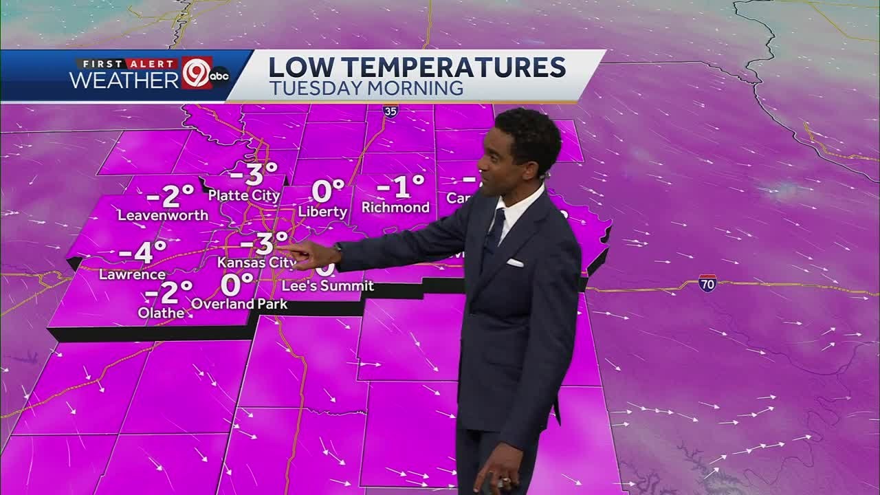
Forecasters are warning residents in Jackson, Clay, Platte, Cass, and Johnson counties to expect wind chills between zero and 10 degrees below zero at various points throughout the weekend. Northern Missouri counties may experience even colder values.
Timeline of Snow and Cold Arrival
Light snow showers will continue through approximately 1 a.m. Saturday. With temperatures dropping quickly, a dusting up to half an inch of accumulation is possible across much of the Kansas City metro. Some isolated pockets could receive slightly more.
By early Saturday morning, the snow activity will taper off, leaving mostly cloudy skies and temperatures in the teens.
However, the wind chill will be the main concern. Winds of 10–15 mph, with gusts up to 30 mph, will make it feel much colder.
Saturday: First Warn Alert for Dangerous Wind Chills
Meteorologists expect Saturday to be the coldest day of the season so far. The Kansas City metro will wake up to temperatures around 14 degrees, but wind chills near or below zero will make conditions potentially hazardous for those spending extended time outdoors.
Residents in northern counties—such as Platte, Clay, Ray, and Clinton—could feel wind chills ranging from 5 to 10 degrees below zero.
While the afternoon will bring limited sunshine, temperatures will only reach the upper teens or near 20 degrees across most of the region. Wind chills will remain in the single digits throughout the day.
Officials advise wearing multiple layers, insulated socks, waterproof boots, gloves, and hats if going outside. Pets should also be kept indoors or monitored closely.
Sunday: Brief Warm-Up Before Another Cold Front
Sunday morning will start in the single digits across the Kansas City metro, with wind chills once again registering between -5 and 0 degrees.
However, unlike Saturday, Sunday will bring a noticeable warm-up in the afternoon. Sunshine will boost temperatures into the low 40s across Jackson, Johnson, Wyandotte, and Clay counties, providing brief relief from the arctic air.
But the warm-up won’t last long.
Sunday Night: Another Cold Front Arrives
Another cold front will move in Sunday night, sending temperatures back into the teens by Monday morning. While this secondary front is not expected to produce heavy snow, it will reinforce the cold pattern and keep daytime temperatures below normal into early next week.
Monday: Cold Start to the Work Week
Monday is expected to begin in the mid-teens, with afternoon highs only climbing into the mid-20s. The main difference from Saturday will be wind speeds—winds should be lighter, reducing wind chill danger.
Even so, temperatures will remain cold enough to require layered clothing for commuters, students, and anyone working outdoors.
Warming Trend Returns Midweek
The region will finally see improvement by Tuesday. Temperatures will climb into the 40s, and the rest of the workweek is expected to remain at or above seasonal averages. Sunshine will return, and no major storm systems are currently forecast for mid to late week.
NEWS FACTS TABLE
| Key Detail | Information |
|---|---|
| Event | Arctic cold front and light snow impacting Kansas City metro |
| Location | Jackson, Clay, Platte, Cass, Johnson (KS), Wyandotte, Leavenworth counties |
| Dates | Friday night through Monday morning |
| Who Is Affected | Residents across Kansas City region and surrounding counties |
| Current Status | First Warn alert in effect; hazardous wind chills expected |
| What Readers Should Know | Expect sub-freezing temperatures, single-digit wind chills, light snow, and dangerous conditions for extended outdoor exposure |
FAQ SECTION (VOICE-SEARCH FRIENDLY)
1. How cold will it get in Kansas City this weekend?
Temperatures will fall into the teens with wind chills near or below zero across the metro. Northern counties may reach -5 to -10 degrees wind chill.
2. Will it snow in Kansas City?
Light snow is expected through early Saturday morning, with a dusting to about half an inch possible.
3. Which counties are under the First Warn alert?
Counties include Jackson, Clay, Platte, Cass, Wyandotte, Johnson (KS), and surrounding areas.
4. When will temperatures warm back up?
A warm-up is expected Sunday afternoon, with temperatures reaching the low 40s before another cold front moves in Sunday night.
5. Will road conditions be dangerous?
Yes. Light snow combined with strong winds and cold temperatures may create slick surfaces and reduced visibility at times.
6. Is more snow in the forecast for next week?
At this time, no major snowfall is expected after the weekend.
7. What should residents do to stay safe in the cold?
Wear layered clothing, limit outdoor exposure, bring pets indoors, and check on vulnerable neighbors.
The Kansas City region will experience a challenging stretch of winter weather as arctic air, light snow, and hazardous wind chills move through the area. While conditions will improve briefly on Sunday afternoon, colder air quickly returns to start the week. Residents should remain alert to rapidly changing conditions and take precautions to stay safe.
More updates will be available as new data becomes available from the National Weather Service and local meteorologists.