GRAND RAPIDS, Mich. — Arctic air is surging into West Michigan, bringing dangerous wind chills, heavy lake-effect snow, and rapidly changing road conditions. The National Weather Service has issued multiple winter storm warnings and advisories through Tuesday morning for areas west of US-131.
Forecasters warn that blowing snow, drifting, and whiteout visibility may create hazardous travel conditions at times. The strongest snow bands are expected to form late Sunday night and continue through Monday morning.
Snow totals will be highest near and west of US-131, where several inches of new accumulation are expected. Meanwhile, wind chills dropping below zero will make conditions even more dangerous for drivers and anyone outdoors.
Arctic Air and Lake-Effect Snow Take Aim at West Michigan
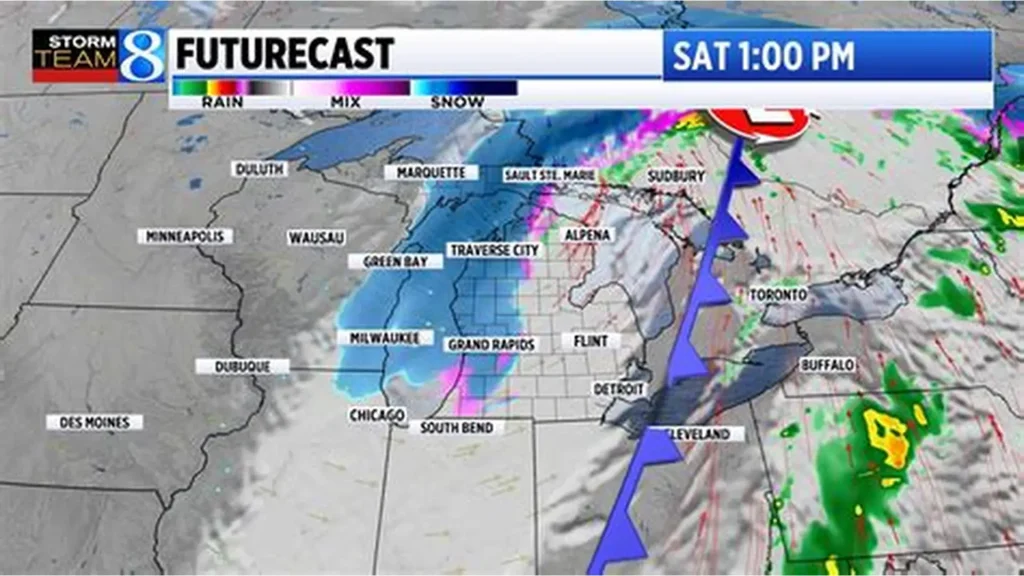
A powerful push of arctic air is moving across the Great Lakes region, bringing sharply colder temperatures and setting the stage for a prolonged lake-effect snow event. West Michigan is positioned directly in the path of the heaviest snow bands, particularly communities along and west of US-131.
The combination of cold air passing over the relatively warmer waters of Lake Michigan and sustained winds above 30 mph is creating ideal conditions for intense lake-effect snow squalls. These squalls can shift quickly, producing periods of near-zero visibility and dangerous driving conditions.
Winter Storm Warnings and Advisories in Effect
Winter storm warnings and winter weather advisories will remain in place through 7 a.m. Tuesday. Officials emphasize that even with moderate snowfall totals, blowing snow will be the primary hazard. Drifting may cause rural roads to become partially or fully blocked, especially in open areas near the lakeshore.
Key impacts include:
- Blowing and drifting snow
- Sudden whiteout conditions
- Below-zero wind chills
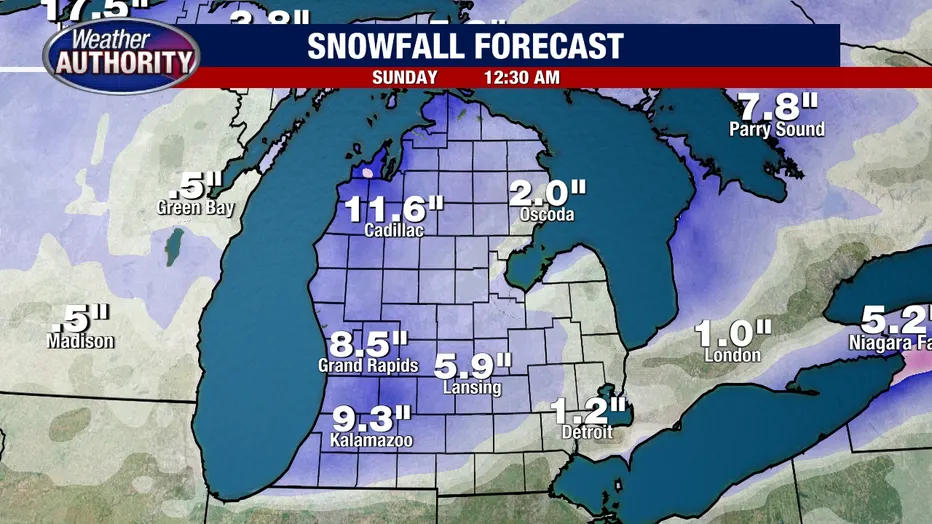
- 4–6+ inches of accumulation in favored snow belts
Lower snowfall totals are expected further inland, but all of West Michigan will experience bitter cold and strong winds.
Where the Heaviest Snow Will Fall
The heaviest and most persistent snow will form along and west of US-131. This includes portions of:
- Kent County
- Ottawa County
- Muskegon County
- Allegan County
- Oceana County
Localized totals could exceed six inches in areas directly under persistent bands. Snowfall rates may reach one inch per hour at times, reducing visibility and creating slick conditions on highways and secondary roads.
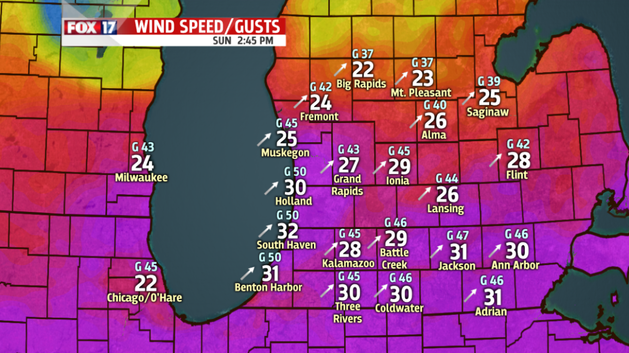
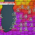
Wind Gusts Creating Additional Hazards
Wind gusts topping 30 mph will significantly worsen travel conditions. These winds will blow snow across open fields, rural roads, and lakeshore communities, creating sudden drifts several feet deep in certain locations.
Whiteout conditions are most likely near the lakeshore, where wind direction and open terrain can amplify blowing snow. Drivers may experience:
- Visibility below 100 feet during squalls
- Rapidly changing road conditions
- Snow-covered lanes
- Drifting causing lane blockages
Motorists are urged to allow extra time, reduce speed, and avoid travel during the heaviest bands if possible.
Timeline of Expected Impacts
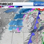
Sunday Night:
Arctic air arrives; snow bands begin forming over Lake Michigan. Initial bursts of heavy snow develop along the lakeshore.
Monday Morning:
Strongest lake-effect snow occurs during the morning commute. Heaviest accumulation forms west of US-131.
Monday Afternoon:
Snowfall becomes less intense but continues in waves. Winds remain strong, causing widespread blowing snow.
Monday Evening:
Gradual decrease in snowfall rates. Wind chills fall below zero overnight.
Tuesday Morning:
Snow bands weaken but bitter temperatures persist. Advisories expire at 7 a.m.
Background: Why This Storm Is Significant
This event follows a pattern of frequent cold fronts sweeping across the Midwest, but the arrival of arctic air marks the coldest outbreak of the season so far. Lake Michigan remains warm enough to produce strong convection and heavy lake-effect bands with the incoming cold air mass.
This combination of cold temperatures, strong winds, and lake-effect snow makes storm conditions unpredictable. Slight changes in wind direction can cause significant shifts in snowfall locations and intensities.
Official Statements and Forecast Notes
Meteorologists emphasize that lake-effect events are highly variable. The National Weather Service states that snowfall totals could vary widely over short distances depending on band placement.
Officials also warn:
- Road crews may have difficulty keeping up with drifting snow.
- Wind chills below zero can be dangerous for exposed skin.
- Additional advisories or warnings may be issued if conditions worsen.
Residents are encouraged to monitor changing conditions closely.
Public Reaction and Local Impact
Residents across West Michigan are preparing for significant travel disruptions. Local officials advise limiting unnecessary travel during periods of heavy snow or blowing snow.
Schools in several communities may consider delays or closures depending on how snow bands evolve overnight into Monday morning. Social media reports already show blowing snow and reduced visibility near open highways and lakeshore roads.
Businesses may adjust hours Monday depending on weather conditions, especially in rural areas where drifting can make travel unpredictable.
What Happens Next
Forecasters expect improving conditions by Tuesday afternoon, but cold temperatures will persist. More flurries or light lake-effect snow showers may linger into mid-week.
Another cold surge remains possible later in the week, though it is too early for specifics. Residents should monitor updated forecasts as the arctic pattern continues.
KEY FACTS TABLE
| Category | Details |
|---|---|
| Event | Arctic air and heavy lake-effect snow |
| Location | West Michigan, especially west of US-131 |
| Date | Sunday night through Tuesday morning |
| Who Is Affected | Drivers, residents, schools, businesses across West Michigan |
| Current Status | Winter storm warnings and advisories in effect |
| What Readers Should Know | 4–6+ inches expected in heaviest bands; whiteouts and below-zero wind chills likely |
FAQ SECTION
1. How much snow will West Michigan get?
Most areas west of US-131 will see 4–6+ inches, with locally higher totals possible under intense bands.
2. When will conditions be worst?
The heaviest snow and lowest visibility are expected Monday morning.
3. Will Grand Rapids get heavy snow?
Grand Rapids will receive several inches, but the heaviest bands will stay west toward the lakeshore.
4. How cold will it get?
Wind chills will fall below zero Monday night into Tuesday.
5. Are whiteouts possible?
Yes. Strong winds and heavy snow will create periodic whiteout conditions, especially near the lakeshore.
6. Will schools close?
Some school districts may delay or close depending on morning band placement.
7. How long will the cold last?
Cold temperatures continue through mid-week with additional cold shots possible later in the week.
West Michigan is preparing for a dangerous mix of arctic air, heavy lake-effect snow, and powerful winds that will impact travel and outdoor activity through Tuesday morning. The most hazardous conditions are likely west of US-131, where strong winds may produce whiteouts and drifting. Residents should stay alert to updated forecasts and plan for slow or difficult travel during the storm’s peak.


Leave a Comment