After several nights of freezing temperatures across Texas, conditions finally began to warm Sunday afternoon. Sunshine and lighter winds allowed much of the state to thaw out after days of icy roads and dangerous wind chills.
But forecasters warn the warmup may be short-lived. Another cold surge is expected after sunset, raising concerns about refreezing on bridges, roads, and vulnerable pipes.
Cities across Central, North, and West Texas are monitoring the next dip in temperatures, which could push many communities back into freezing territory overnight. The National Weather Service continues to issue alerts urging residents to prepare for the possibility of another cold night.
This temperature rollercoaster matters because rapid warming and cooling can create hazardous travel conditions and strain infrastructure already stressed from the recent cold blast.
Texas Sees Sunday Warmup After Days of Freezing Conditions
Texas residents welcomed a noticeable warmup Sunday afternoon following several days of below-freezing temperatures. The shift came as a cold, stagnant air mass began to move east, allowing milder, drier conditions to push into the state.
By early afternoon, temperatures climbed into the upper 40s and low 50s across portions of Central and East Texas. North Texas saw temperatures near the mid-40s, while South Texas warmed into the 60s. Sunshine returned for many communities, providing some relief after a stretch of icy mornings.
This temporary improvement allowed road crews to continue clearing remaining ice patches, and residents used the warm hours to complete outdoor tasks before colder air returns later tonight.
Why Another Freeze Is Still on the Table
Despite Sunday’s warmer temperatures, overnight conditions are expected to drop quickly after sunset. Clear skies will allow heat to escape rapidly, creating what meteorologists call “radiational cooling.” This effect can lead to temperatures falling 15 to 20 degrees within a few hours.
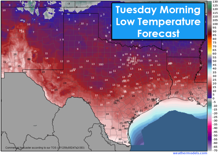
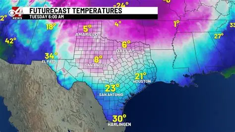
Forecasters say another freeze is possible across large portions of Texas, particularly in the Panhandle, North Texas, West Texas, and parts of Central Texas. Even regions that warm above freezing during the afternoon may slip back below 32 degrees during the early morning hours Monday.
Wind speeds are expected to be lighter tonight, which can lead to colder overnight lows. Some rural areas may fall several degrees colder than nearby cities.
Timeline of Weather Changes
Sunday Morning
Temperatures began in the upper teens and 20s across much of the state. Icy patches remained on bridges, shaded roads, and elevated surfaces. Wind chills made conditions feel significantly colder.
Sunday Afternoon
A noticeable warmup occurred as skies cleared and winds shifted. Road conditions improved statewide, and melting increased in urban areas. Many regions experienced their warmest temperatures in days.
Sunday Evening
Cold air starts to return after sunset. Temperatures fall rapidly under clear skies. Areas that reached the 50s may dip into the 30s by early evening.
Overnight Into Monday Morning
Many counties face a renewed freeze risk. Refreezing is likely on elevated structures, especially where melting occurred earlier. Frost may develop on vehicles and exposed surfaces.
Official Weather Guidance and Alerts
The National Weather Service continues monitoring conditions closely and has issued guidance for residents in areas likely to see another freeze. While not all regions are under a formal freeze warning, many are under “hazardous weather outlooks,” which alert communities to rapid temperature drops and potential refreezing.
Local emergency management teams are advising residents to protect pets, plants, and outdoor plumbing. Water utilities in North Texas and Central Texas have reminded customers to insulate exposed pipes and allow slow water drips if temperatures drop below freezing again.
Texas Department of Transportation (TxDOT) crews are prepared for overnight refreezing, especially on bridges and overpasses. Drivers are urged to slow down and use caution early Monday morning.
How Residents Are Responding
Public reaction across Texas has been mixed. Many residents welcomed the brief warmup but expressed concern about fluctuating temperatures returning overnight. On social media, drivers shared photos of lingering ice patches still present on shaded roads.
Some homeowners took advantage of Sunday’s warmer conditions to repair insulation, patch pipes, and check water lines after damage from recent freezes. Utility companies have reported a steady volume of calls regarding frozen pipes, though fewer than during previous, more severe winter outbreaks.
Businesses that rely on outdoor operations—such as construction, landscaping, and transportation—used Sunday afternoon to resume normal schedules before potential delays Monday morning.
Why Texas Weather Shifts So Quickly
Texas is prone to large temperature swings due to its geography. Cold air from the northern U.S. can sweep southward rapidly, especially when guided by strong upper-level systems. Once the core of a cold air mass moves east, warmer air from the southwest can quickly replace it, leading to sudden rebounds in temperature.
This pattern often repeats several times during winter, making freeze-thaw cycles common across the state. These fluctuations can increase risks for ruptured pipes, weakened roadways, and hazardous driving conditions.
What Happens Next
Forecasters are watching another weak cold front expected midweek, which could bring additional nights near or below freezing for portions of North and Central Texas. While the next system is not expected to be as severe as last week’s arctic blast, it may prolong cold morning temperatures.
Residents are encouraged to stay updated on local forecasts, especially overnight lows. Schools and employers in some regions may adjust start times if conditions become icy again Monday morning.
Meteorologists caution that even a brief warmup does not eliminate the risks associated with winter weather patterns. Continued monitoring is advised through the early part of the week.
NEWS SUMMARY TABLE
| Key Info | Details |
|---|---|
| Event | Texas warms Sunday afternoon but faces potential overnight freeze |
| Location | Statewide; highest risk in North, Central, West Texas |
| Date | Sunday into Monday morning |
| Who Is Affected | Drivers, homeowners, utilities, businesses |
| Current Status | Temperatures rising during afternoon but expected to drop overnight |
| What Readers Should Know | Prepare for possible refreezing; monitor local alerts |
FAQ SECTION
1. Will Texas freeze again tonight?
Many parts of Texas may fall below freezing overnight due to clear skies and rapid cooling.
2. Which areas are most at risk?
North Texas, West Texas, the Panhandle, and parts of Central Texas are most likely to see another freeze.
3. Will roads refreeze overnight?
Yes. Melted snow or ice can refreeze on bridges, elevated roads, and shaded areas.
4. How warm did Texas get Sunday afternoon?
Most regions warmed into the 40s and 50s, with South Texas reaching the 60s.
5. Should homeowners protect pipes again?
Yes. If temperatures drop below 32 degrees, exposed pipes should be insulated or allowed to drip slowly.
6. Will schools be affected Monday?
Some districts may see delays if icy conditions develop, depending on local temperatures.
7. When does a longer warmup arrive?
A gradual warming trend is expected later in the week, though morning freezes may continue in some regions.
CLOSING
Texas saw a brief break from freezing temperatures on Sunday, but forecasters emphasize that another cold night remains possible. Residents should plan for rapidly falling temperatures after sunset and monitor overnight forecasts closely. Additional updates will be issued if conditions change or new alerts are posted.


Leave a Comment