A rare winter event unfolded across parts of Florida on Sunday as snowfall coated portions of the Panhandle for the second consecutive year.
Residents in Pensacola and surrounding areas woke up to white-covered rooftops, icy roads, and temperatures far below seasonal averages.
The National Weather Service confirmed that up to 2 inches of snow fell across southern Alabama and parts of the Florida Panhandle early Sunday morning.
The snowfall is significant not only because of Florida’s typically warm climate but also because it arrives almost exactly one year after a record-breaking snow event hit the region in January 2025.
Forecasters warn that freezing temperatures will continue through early this week, bringing extended cold risks to vulnerable residents, agriculture, and transportation systems.
Local officials are urging caution as wind chills make conditions feel even colder.

Rare Snowfall Returns to Florida as Arctic Air Mass Stalls Over the Southeast
For the second winter in a row, parts of Florida experienced snowfall—an increasingly uncommon occurrence in the Sunshine State’s modern climate history. The surprising winter weather began early Sunday as an upper-level low pressure system moved across the Gulf Coast, pushing unusually cold Arctic air deep into the South.
According to the National Weather Service (NWS), areas in southern Alabama and the Florida Panhandle reported measurable snow accumulation, with Pensacola observing up to 2 inches by mid-morning. Photos and videos circulating on social media showed cars coated in snow, icy bridges, and residents bundled up as temperatures fell into the mid-20s.
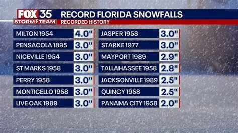
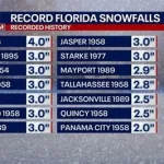
The Florida Panhandle is no stranger to cold fronts, but snow remains rare. Historically, measurable snowfall in Florida occurs only a handful of times per decade, largely limited to the northernmost counties. Sunday’s event marks the second consecutive January in which Florida has experienced snow following the significant accumulation of 6 to 8 inches recorded in Pensacola in January 2025.
Strong Arctic Air Behind This Unusual Winter Event
Meteorologists report that the snowfall resulted from a combination of moisture from the Gulf of Mexico and a strong blast of Arctic air plunging unusually far south. This weather pattern allowed precipitation to fall as snow instead of cold rain.
The NWS explained that the cold-air mass had already settled over the region before the storm system arrived, creating ideal conditions for snow formation. Temperatures in the Florida Panhandle dipped to the low 20s overnight, with wind chills making it feel even colder.
The front is expected to stall over the Southeast through early week, maintaining freezing temperatures during the morning and overnight hours. In some inland areas, frost and hard freeze conditions are possible.
Timeline of the Winter Weather System
Saturday Evening:
Cold air began pushing into the western Florida Panhandle as wind speeds increased. Moisture started to build over the Gulf.
Early Sunday Morning:
Snow began falling shortly after sunrise, first appearing in southern Alabama and gradually spreading across the Panhandle. Light accumulation was observed within hours.
Mid-Morning Sunday:
The heaviest snow occurred from 6 a.m. to 10 a.m., with Pensacola reporting up to 2 inches. Roads became slick, and law enforcement agencies issued advisories for drivers.
Sunday Afternoon:
Temperatures hovered near freezing, preventing significant melting. Clouds cleared, leaving roads icy into the evening.
Sunday Night into Monday:
Freezing temperatures persisted, prompting frost and freeze warnings across the region.
Impact on Residents, Roads, and Local Infrastructure
While the snowfall was relatively light compared to last year’s event, it still caused minor disruptions across northwest Florida. The Florida Highway Patrol warned drivers of icy patches on bridges and overpasses—areas particularly vulnerable during cold weather.
Municipal offices reported delays for early-morning operations, and several schools announced they were monitoring conditions for potential schedule adjustments. Airports in the region remained open but encouraged travelers to check for delays.
Residents reported power outages in isolated areas as icy conditions put strain on utility infrastructure. Cold temperatures also posed risks for exposed pipes, prompting officials to advise residents to drip faucets and insulate outdoor plumbing where possible.
Local shelters in Pensacola and nearby communities extended their hours to provide warmth to residents experiencing homelessness or inadequate heating.
Public Reaction and Social Media Response
Social media platforms lit up with images of snow-covered palm trees, snowy backyards, and children playing in the rare winter weather. Many residents expressed surprise and excitement, as snowfall remains a novelty in Florida.
However, others voiced concerns about icy travel conditions and the lingering cold. Many were reminded of the 2025 storm that brought unusually heavy accumulation and caused widespread freezing damage to crops and infrastructure.
Meteorologists emphasized that while snowfall events are still rare in Florida, fluctuations in atmospheric patterns can occasionally bring Arctic air masses farther south than typical.
How This Year’s Snowfall Compares to 2025’s Record Event
The January 2025 snowfall remains one of the most significant winter events in Florida’s modern climate record. Pensacola received 6 to 8 inches—a level not seen in decades. Sunday’s snowfall did not reach the same intensity but is notable for occurring almost exactly one year later.
Experts say back-to-back snow events are uncommon but not unprecedented. The combination of a strong jet stream pattern and cold air intrusions can create conditions favorable for snow if moisture aligns at the right time.
Forecast: Freezing Temperatures to Continue Through Midweek
According to the NWS, freezing temperatures will persist across the Florida Panhandle and parts of northern Florida through at least Tuesday morning. Overnight lows could dip into the low 20s in inland areas and the upper 20s along the coast.
Agricultural producers, especially those managing sensitive crops and livestock, are urged to implement freeze protection measures. Pet owners are advised to keep animals indoors, and residents are cautioned to avoid using unsafe heating methods.
Wind chills may remain dangerous during early mornings, increasing the risk of hypothermia and frostbite for anyone outdoors for extended periods.
NEWS SUMMARY TABLE
| Key Detail | Information |
|---|---|
| Event | Rare snowfall and ongoing freeze in parts of Florida |
| Location | Florida Panhandle, including Pensacola |
| Date | Sunday morning, January (second consecutive year) |
| Who Is Affected | Residents, travelers, vulnerable populations, agriculture |
| Current Status | Up to 2 inches of snow; freezing temperatures continue |
| What Readers Should Know | Cold weather persists into early week; icy roads and frost risk |
FAQ SECTION
1. Why is Florida getting snow again?
A strong Arctic air mass pushed farther south than usual, combining with Gulf moisture to produce snow.
2. How much snow fell in Florida?
Up to 2 inches were reported in parts of the Panhandle, primarily around Pensacola.
3. Will the freezing temperatures continue?
Yes. The National Weather Service expects below-freezing temperatures through early week.
4. Is this snowfall normal for Florida?
No. Snowfall remains rare in Florida and typically occurs only in far northern areas.
5. Will schools or businesses close?
Most remain open, but some may adjust hours depending on road conditions.
6. Is this related to last year’s record snow?
Not directly, though similar atmospheric patterns contributed to both events.
7. What should residents do to stay safe?
Limit early-morning travel, use safe heating methods, protect pipes, and check on vulnerable individuals.
Snowfall in Florida is always noteworthy, and this year’s event underscores how quickly winter weather can change across the Southeast. With freezing temperatures expected to continue through midweek, officials urge residents to stay informed and take precautions against cold-related hazards.
Forecasters will continue monitoring the Arctic air mass and any additional moisture that could influence conditions in the coming days.


Leave a Comment