ROCHESTER, N.Y. — A long-duration lake effect snow event is developing west of Rochester, and forecasters warn that conditions may rapidly deteriorate in the most persistent bands. Heavy snow squalls, strong winds, and near-whiteout visibility are likely from Orleans County to Genesee, Wyoming, and areas closer to Buffalo.
The National Weather Service says snow totals may exceed one foot in areas directly under the bands, with even higher amounts possible near Lake Erie. Blowing and drifting snow will make travel along the New York State Thruway extremely hazardous at times.
While Rochester itself will see significantly lighter snowfall, the region will still experience bitter cold, strong winds, and dangerous wind chill values through mid-week. Another surge of arctic air is expected late Thursday, extending the stretch of cold into next weekend.
Long-Duration Lake Effect Snow Event Setting Up West of Rochester
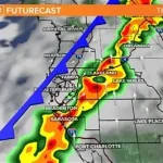
A prolonged lake effect snow event is taking shape across western New York, with meteorologists tracking multiple intense snow bands forming off Lake Erie. These bands are expected to drift and meander for several days, repeatedly impacting communities west of Rochester. Areas within Orleans, Genesee, and Wyoming Counties are expected to see the greatest impacts and highest snow accumulation.
The setup is typical of mid-winter patterns when cold arctic air crosses the relatively warmer waters of the Great Lakes. The temperature contrast fuels narrow but powerful snow bands capable of dropping several inches of snow per hour. Forecasters emphasize that conditions can change quickly based on the movement of these bands.
Where the Heaviest Snow Will Fall
The heaviest snowfall is expected across:
- Orleans County
- Genesee County
- Wyoming County
- Areas west toward Buffalo and the Lake Erie shoreline
Residents in these zones may experience visibility near zero during the most intense periods. Snowfall rates could reach two to three inches per hour inside the core of the bands, especially Monday night into Tuesday morning.
Communities closer to Lake Erie are likely to see totals exceeding one foot, with localized amounts possibly surpassing 18 inches in the hardest-hit corridors.
New York State Thruway Travel Expected to Be Hazardous
Travel risks will increase significantly along the New York State Thruway, particularly west of Rochester toward Batavia. Officials warn of:
- Rapid changes in visibility
- Slippery and snow-covered roadways
- Blowing and drifting snow
- Sudden near-whiteout conditions
Drivers are advised to use caution, allow extra travel time, and avoid unnecessary travel when heavy bands are overhead. Road conditions may appear manageable one moment and become dangerous minutes later due to shifting snow squalls.
Winter Storm Warning Issued
The National Weather Service has issued a Winter Storm Warning for communities expected to see the highest snow impacts. The warning covers parts of western New York where heavy lake effect snow, blowing snow, and hazardous wind chills are expected.
Warnings generally remain in effect through mid-week, with updates issued as bands shift and intensify.
Rochester Area to See Lighter Snow, But Bitter Cold
In comparison, the immediate Rochester metro area will see lower snowfall totals. Most towns across Monroe County will measure only one to three inches through mid-week. While snow accumulation will be light, dangerous cold and strong winds will create additional concerns.
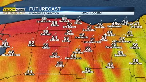
Winds are expected to gust near 40 miles per hour, especially Monday afternoon through Tuesday. The combination of cold temperatures and strong wind will push wind chill values near zero and even below zero at times.
Residents are encouraged to limit time outdoors, secure loose outdoor items, and prepare for sharply colder conditions.
Timeline of Expected Weather Impacts
Monday Afternoon:
Lake effect bands intensify west of Rochester. Winds increase across the region.
Monday Night:
Heaviest snow begins in Orleans, Genesee, and Wyoming Counties. Visibility reduces quickly.
Tuesday:
Bands drift and redevelop. Persistent snow continues west of Rochester. Bitter cold spreads east.
Wednesday:
Snow eases temporarily. Winds decrease slightly. Temperatures moderate but remain below average.
Late Thursday:
Another surge of arctic air arrives. Temperatures drop sharply again through the weekend.
Official Statements and Forecast Guidance
Meteorologists continue to stress the unpredictable nature of lake effect snow. Slight shifts in wind direction can dramatically alter which towns receive the heaviest snowfall.
Forecasters note that:
- Snowfall totals may vary widely over short distances.
- Heaviest snow is expected to remain west of Rochester.
- Additional warnings or advisories may be issued as conditions evolve.
Local agencies also warn residents to prepare for possible delays, power fluctuations from strong winds, and challenging travel conditions.
Public Reaction and Local Impact
Residents in western New York are accustomed to lake effect snow, but long-duration events often create significant challenges. Local social media reports show drivers already encountering reduced visibility and drifting snow near open fields and rural roads.
Businesses in affected counties may adjust hours depending on road conditions. Schools could face delays or closures if bands stall over specific districts.
Meanwhile, residents in Rochester express concern more about the extreme cold than snow accumulation. Many are preparing for the possibility of dangerous wind chill values and icy roads.
What Happens Next
Forecasters expect additional updates as snow bands continue shifting. Weather models show another round of arctic air arriving late Thursday, bringing even colder temperatures through next weekend.
Residents are advised to continue monitoring updated forecasts, weather alerts, and travel advisories, especially those commuting along the Thruway corridor west of Rochester.
KEY FACTS TABLE
| Category | Details |
|---|---|
| Event | Long-duration lake effect snow event |
| Location | Orleans, Genesee, Wyoming Counties; areas west of Rochester, NY |
| Date | Monday through mid-week |
| Who Is Affected | Drivers, residents, schools, businesses across western NY |
| Current Status | Winter Storm Warning in effect; intense snow bands developing |
| What Readers Should Know | Up to a foot or more of snow west of Rochester; whiteout travel possible; bitter cold for entire region |
FAQ SECTION
1. How much snow will western New York receive?
Areas west of Rochester may see more than a foot of snow, with higher totals closer to Lake Erie.
2. Will Rochester get heavy snow?
No. Most of Rochester will see only one to three inches, but cold and wind will be significant.
3. Is travel safe along the Thruway?
Travel may be hazardous at times, especially between Rochester and Batavia during heavy snow squalls.
4. When will conditions improve?
Snow intensity should decrease by Wednesday, but another arctic blast arrives late Thursday.
5. What should residents prepare for?
Strong winds, blowing snow, dangerous wind chills, and rapidly changing conditions in snow bands.
6. Will schools close?
Closures are possible in hardest-hit counties depending on snow band location and timing.
7. Are more warnings expected?
Additional advisories or warnings may be issued as conditions evolve.
Western New York is entering a volatile weather pattern marked by heavy lake effect snow, bitter cold, and strong winds. Communities west of Rochester will see the greatest snow impacts, while the Rochester metro area deals primarily with wind and dangerous wind chills. Conditions will fluctuate through mid-week, followed by another round of arctic air late Thursday. Residents should stay updated on forecasts and travel advisories as weather conditions evolve.


Leave a Comment