Michigan Weather Radar Update: Current Conditions Amid Severe Thunderstorms Across the State
Michigan is familiar with violent and unpredictable weather. From blizzards and flash flooding to surprise tornadoes and the unexpected veil of smoke from wildfires, the state has a tendency to keep folks guessing. Staying true to form, Michigan is once again experiencing an extreme weather pendulum swing as severe thunderstorms sweep across the state.
Late Friday night well into early Saturday, a severe storm system moved through the state, bringing severe lightning, heavy rain, and potential tornadoes. Multiple tornado warnings were issued because of the developing storm system, showing just how desperate the circumstances were. Livingston County was under tornado warning until 12:45 a.m., northern Oakland County until 1:15 a.m., and Lapeer County until 1:30 a.m. They were told to take cover at once since things might go wrong in a matter of moments.
This type of rapid weather shift is not typical of Michigan, which has accustomed itself to seeing extreme levels of temperature and storm intensity shift within hours. That is precisely the reason why it is extremely important to stay updated and look at the latest information in real-time.
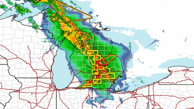
For those who love to keep their eyes on the horizon, the National Weather Service offers a live Doppler radar feed so you can watch minute-by-minute movement of the storm. The radar gives you a window to look at current conditions across the state and get an idea where the worst rain and greatest wind are striking and whether your own neighborhood could be next.
If your area is under a tornado warning, it’s important to act quickly. Move to a basement or an interior room without windows, and avoid staying in vehicles or mobile homes during the storm. Keep a battery-powered weather radio or charged mobile device with emergency alerts enabled so you’re notified as situations evolve.
In addition to the actual threat, there are also typically accompanying issues such as power outages. You can check when the power will come back on by going to your local electric utility company website or power outage map. Some power companies now even offer interactive maps showing where there are major outages. They also give estimated times of restoration.
In addition, keep an emergency kit handy, including flashlights, extra batteries, bottled water, canned food, and any medications that have been prescribed. Given Michigan’s as-cold-as-it-is-weather, you can never have enough preparedness for the unexpected.
Whether you look up at the sky or glance at the news on the web, staying informed and ready is the ticket to riding out Michigan storms. Stay safe, stay vigilant, and watch the radar.