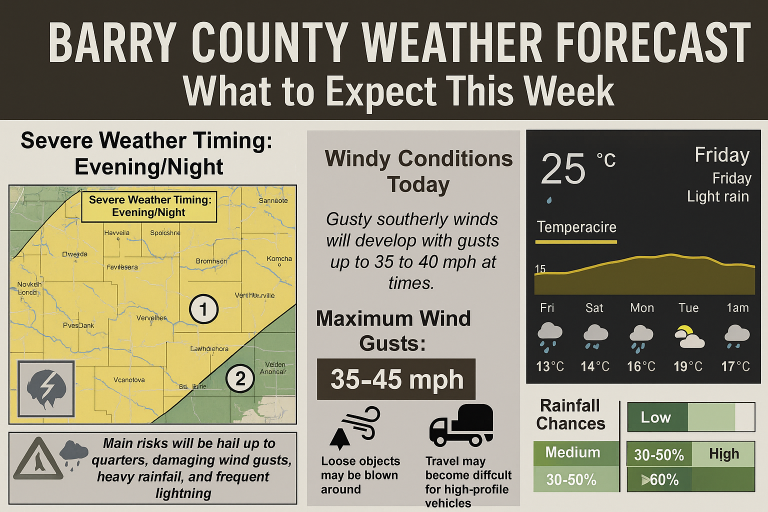
Barry County Weather Alert: Rainy Days Ahead with Thunderstorms and Heavy Rainfall
Barry County residents, get ready for a stretch of wet and stormy weather this week. If you’ve got outdoor plans or travel coming up, it might be a good idea to keep an umbrella close and an eye on the sky. According to the latest forecast, the region is in for multiple days of rain, thunderstorms, and even the potential for heavy downpours.
Let’s discuss what you should be keeping an eye out for these next few days so you can stay prepared and safe.
Tonight: Rain and Thunderstorms Rolling In
It will not be a quiet minute tonight, not even close. There should be rain occurring all night long throughout the evening hours, with periodic thunderstorms rolling on by. A few of them will contain heavy rain, so wandering into flood areas isn’t in the equation. With lows in the low 60s and east winds at 5 to 10 mph, it’ll be a wet but lightly windy evening. Chances of rain are highly probable well over 90% – so it’s definitely a night to remain indoors if at all possible. Wednesday: A Stormy Day Ahead
Wednesday will be a stormy day from sunrise until sundown. There will be a group of showers and isolated thunderstorms in the morning that will pass over Barry County, and short of a miracle, the afternoon won’t be much better. There will be large regions of thunderstorm activity, and several of them will have the potential to bring heavy rain. If you drive to work, are on business travel, or driving around running errands, expect potentially bad road conditions from rain and reduced visibility.
Temps will warm up into the low 70s, and the winds will begin in the southeast at 5 to 10 mph before the wind makes a shift south during the day. Gusts will be gusting to 25 mph, so don’t leave your hats behind! There is a 90% chance of precipitation today, so all but a handful of spots should see some measurable precipitation.
Wednesday Night: More Thunderstorms
If it’s going to shrink down during nighttime, forget about it. Wednesday evening will be an extension of more of the same—shower and copious amounts of thunderstorms right on into evening hours. There will be some of the storms that still feature heavy rain, and as a result, flash flooding remains on the agenda to watch for, particularly over the low areas of ground with inadequate drainage.
Temps will fall into the mid-50s, but gusty south winds will still hit 25 mph. Rain is again probable with a 90% chance, so expect another night of awful weather.
Thursday: A Mix of Storms and Sunshine
Thursday itself is a day in between. During the morning of the day, there will be rain and thunderstorms and again heavy rain will be present. But after that, perhaps it should get clear some during the afternoon. The weather is predicting showers and thunderstorms possible, but the sky would partly clear to become sunny later.
With highs in the low 70s and a blustery west wind with a top speed of 10 to 15 mph, it will begin to get a bit more bearable—at least shower-to-shower. There still remains a 70% chance of rain, particularly this morning.
Thursday Night: Light Calm during the Rain
Things start to slow down a bit Thursday evening. Skies become partly to mostly cloudy, and although there is no to little possibility of experiencing one or two thunderstorms late tonight, most of the rain gets erased. Tempers drop back into the mid-50s, and northwest winds taper off to 5 to 10 mph. Rain possibilities drop to about 20%, so it’s a good night to slow down and dry off a bit.
Friday: Blue Sky and Smoother Weather
A respite from the stormy spell comes this Friday. Early morning may have some showers, but after that, it’s going to be ultra sunny afternoon and nighttime. High temperatures will be around 70s – a nice temperature for this time of year. Rain probabilities drop to around 30%, and that too in only the morning half of the day. It’s going to be a peaceful and pretty day overall compared to the first two.
Weekend Outlook: At Last, Some Sunshine
The forecast? The weather this weekend is much better. Friday evening through Sunday, mostly sunny. Overnight lows will be mid-40s, i.e., cool, crisp nights. Daytime highs will be in the lower 70s – ideal for going out after a soggy week.
Early Next Week: Mild and Mostly Sunny
A peek at next week, the warm sunny sunshine Monday highs in the mid-70s range – beautiful spring weather. Partly cloudy Monday night will drop to the mid-50s. Tuesday more sun and with a very low probability for afternoon thunderstorm showers, with the upper 70s high. Tuesday rain chance is around only 20%, so this seems to be another otherwise great day.
Stay Safe and Stay Informed
With all the water all around and the possibility of heaving thunderstorms, precautions need to be taken. Keep an eye out for local warnings, particularly if you are in flood-prone zones. Keep emergency supplies in good working order, and driving, go slowly on roads and use longer routes traveled.
Barry County has seen its share of rough weather, but with some planning and community awareness, we’ll weather this stormy stretch just fine. Here’s hoping for drier days ahead and soon!