Tampa Bay Weather Alert: Freeze Warning Issued as 40+ MPH Wind Gusts Set to Hit Sunday
Scattered showers and a sharp temperature drop are expected across the Tampa Bay area on Sunday, bringing a rapid shift from mild morning rain to dangerously cold conditions by nightfall. Forecasters warn that strong wind gusts and freezing temperatures could create hazardous conditions for residents across Hillsborough, Pinellas, Pasco, Hernando, Manatee, and Sarasota counties.
The National Weather Service has issued both a Freeze Warning and Cold Weather Advisory from midnight through 9 a.m. Monday as temperatures plunge into the mid-20s in some inland locations. Wind chills could fall even lower, posing risks to vulnerable residents, pets, and unprotected plants.
This pattern follows a weekend of unstable weather across West Central Florida, as southerly winds quickly shift to a strong northerly flow by midday Sunday. The resulting cold surge is expected to be the most significant the Tampa Bay region has experienced this season.
Officials urge residents to prepare now, as conditions will deteriorate quickly overnight.
Scattered Morning Showers Set the Stage for a Dramatic Weather Shift
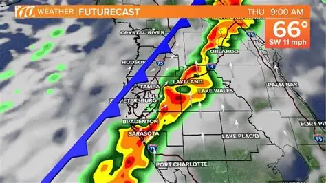
The Tampa Bay area will begin Sunday with scattered showers and pockets of light rain extending across Hillsborough, Pinellas, Pasco, and Manatee counties. Rainfall is not expected to be heavy, but moisture will linger across the region until late morning.
By noon, conditions will begin to improve as showers clear out and skies become partly to mostly cloudy. Temperatures early in the day will remain mild, hovering in the upper 50s and low 60s before the cold front pushes through.
Southerly Winds Shift to a Strong Northerly Push
Forecasters emphasize that one of the most notable features of Sunday’s weather is the abrupt wind shift. Southerly winds between 10 and 15 mph will dominate early in the morning. However, between 10 a.m. and noon, winds will quickly shift to the north.
Once the northerly flow establishes itself, sustained winds of 20–25 mph are expected, with gusts exceeding 40 mph in coastal counties. These strong winds will accelerate the arrival of cold air into the Tampa Bay region, setting the stage for an unusually frigid night.
Gusty winds could cause issues such as:
-
Hazardous driving conditions on bridges and elevated roadways
-
Spotty power outages due to weakened tree limbs
-
Difficult conditions for boaters along the Gulf Coast
Mariners are warned to avoid small crafts during peak wind gusts, as conditions will be dangerous.
Freeze Warning and Cold Weather Advisory Issued
A significant Arctic air mass will settle over Florida late Sunday night, prompting the National Weather Service to issue a Freeze Warning and Cold Weather Advisory from midnight to 9 a.m. Monday.
Temperatures could drop as low as 25 degrees in parts of inland Pasco, Hernando, and northern Hillsborough counties. Coastal areas will remain slightly warmer but still below seasonal averages, with lows in the upper 20s to low 30s.
Wind chills will make conditions feel even colder, with values dropping to 23 degrees or lower in several locations.
The cold spell is especially noteworthy because:
-
Many Tampa Bay residents are unaccustomed to prolonged freezing temperatures
-
Sensitive vegetation and crops could sustain damage
-
Pets could be at risk if left outdoors
-
Homeless shelters may experience increased demand
Local officials encourage residents to protect people, pets, plants, and pipes—the four key categories typically affected during Florida freeze events.
Timeline of Expected Weather Changes
Sunday morning (6 a.m.–12 p.m.):
-
Scattered showers across Tampa Bay
-
Southerly winds at 10–15 mph
-
Mild temperatures
Late morning to early afternoon (10 a.m.–2 p.m.):
-
Winds shift to the north
-
Gusts exceed 40 mph
-
Temperatures begin to fall
Sunday evening (5 p.m.–10 p.m.):
-
Rapid temperature drop
-
Skies remain partly cloudy
-
Freezing wind chills develop
Overnight into Monday morning (12 a.m.–9 a.m.):
-
Freeze Warning in effect
-
Lows between 25–32 degrees
-
Wind chills down to 23 degrees
What Local Officials Are Saying
Meteorologists and emergency management personnel stress the need for preparation. Although no major storm system is expected, the combination of freezing temperatures and high winds is uncommon for West Central Florida.
Local counties have issued guidance reminding residents to:
-
Bring pets indoors
-
Cover outdoor pipes and irrigation lines
-
Protect tropical plants
-
Check on elderly neighbors or those without heating
School and government offices were not expected to close as of the latest update, but officials note that early Monday morning commutes could be colder than usual.
Public Reaction and Concerns
Residents across Tampa Bay expressed surprise at the sudden shift. Social media posts highlight concerns about:
-
Unpreparedness for freezing conditions
-
Potential impacts on gardens and landscaping
-
Safety of outdoor animals
-
Overnight shelter availability
Many agricultural growers in Hillsborough and Manatee counties are preparing frost protection measures, including irrigation and crop coverings.
What Happens Next
Temperatures are expected to remain colder than average through early next week, though the worst of the freeze conditions should subside by Monday afternoon. Winds will gradually diminish, and daytime highs will recover to the 50s and low 60s by midweek.
However, meteorologists warn that additional cold fronts may arrive later in the week, keeping nighttime temperatures lower than normal.
KEY FACTS TABLE
| Key Detail | Information |
|---|---|
| Event | Scattered showers, strong winds, Freeze Warning |
| Location | Tampa Bay area (Hillsborough, Pinellas, Pasco, Hernando, Manatee, Sarasota) |
| Date | Sunday morning through Monday morning |
| Who Is Affected | Residents, travelers, boaters, farmers, pets |
| Current Status | Advisory and Freeze Warning active |
| What Readers Should Know | Strong winds + freezing temps may cause hazards |
FAQ SECTION
1. How cold will it get in Tampa Bay on Monday morning?
Temperatures may drop to 25–32 degrees depending on the county, with wind chills as low as 23 degrees.
2. How long will the Freeze Warning last?
The Freeze Warning is active from midnight to 9 a.m. Monday.
3. Will the morning rain cause flooding?
No significant flooding is expected. Rainfall will be light and scattered.
4. What areas will see the strongest winds?
Coastal counties such as Pinellas, Sarasota, and Manatee may experience gusts above 40 mph.
5. Should residents protect plants and pipes?
Yes. Temperatures below freezing can damage tropical vegetation and uninsulated pipes.
6. Will roads be icy?
Icy roads are unlikely, but strong winds may make driving hazardous on bridges and cause debris.
7. When will temperatures warm up again?
Temperatures will begin recovering Monday afternoon and continue warming through midweek.
The Tampa Bay region faces a rapid and significant weather shift as scattered showers give way to freezing temperatures, dangerous wind chills, and strong northerly winds. Residents are advised to take all necessary precautions ahead of Sunday night, especially to protect vulnerable populations, pets, and sensitive plants. Conditions will gradually improve early next week, but more cold air may follow.