New Jersey Snow Alert: 2–5 Inches Expected Today as 2nd Winter Storm Hits Bergen, Essex, and Hudson Counties
New Jersey is facing a second winter storm in as many days, with widespread snowfall expected across the state Sunday. Forecasters predict 2 to 5 inches of snow for much of northern and central New Jersey, with coastal areas seeing slightly lower totals.
The coastal storm has already begun before sunrise and will continue throughout the day, impacting commuters, travelers, and residents. Winter Weather Advisories remain in effect for Bergen, Essex, Hudson, Passaic, Union, and several other counties.
This comes after parts of northern New Jersey received 3 to 5 inches of snow Saturday, with Warren and Sussex counties reporting the highest totals. Snowfall from the second storm may exacerbate travel disruptions and create hazardous road conditions.
Residents are urged to monitor updated forecasts, plan for slower travel, and remain cautious on roads and sidewalks as the storm progresses.
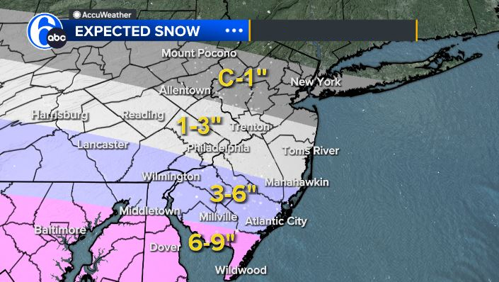
Snow Totals Forecast Across New Jersey
Sunday’s coastal storm is expected to blanket much of New Jersey with moderate snowfall:
-
Bergen, Essex, Hudson, Passaic, and Union Counties: 3–5 inches, advisories until midnight
-
Camden, Gloucester, Salem, and northwestern Burlington Counties: 2–4 inches, advisories until 8 p.m.
-
Hunterdon, Mercer, Morris, Middlesex, Somerset, and western Monmouth Counties: 2–5 inches, advisories until 8 p.m.
-
Sussex and Warren Counties: 2–4 inches, advisories until 8 p.m.
Across Long Island, snowfall totals are expected to range 2–5 inches for the North Shore and western parts of the island, and 1–3 inches for the South Shore and eastern Long Island.
Central Jersey and the Jersey Shore are forecasted to see 2–5 inches inland and 1–3 inches along the coast, while northern New Jersey, the Lower Hudson Valley, and Connecticut will likely record 2–5 inches. Upper Hudson Valley and far northwestern New Jersey may see 1–3 inches.
Storm Background
The coastal storm follows a prior snow event Saturday that delivered 3–5 inches of snow across northern New Jersey, with Warren and Sussex counties seeing the heaviest totals. Snowfall accumulation varied widely due to local elevation differences and proximity to the coast.
Meteorologists have tracked the second system moving up the Mid-Atlantic coastline, bringing snow inland early Sunday morning. While this storm is not expected to be as disruptive as major nor’easters, it is enough to impact morning commutes, school transportation, and weekend activities.
Timeline of Today’s Snow Event
Before Sunrise
Snow began falling before dawn, primarily across northern counties including Bergen, Essex, and Hudson. Light to moderate snow initially accumulates on untreated roads. Coastal areas see rain or mixed precipitation early due to slightly warmer temperatures.
Morning (6 a.m.–10 a.m.)
Snow continues to expand across central New Jersey and the Lower Hudson Valley. Light snow transitions to moderate intensity inland. Advisory counties such as Hunterdon, Mercer, and Morris begin to see accumulations nearing 1–2 inches.
Midday (10 a.m.–2 p.m.)
Snowfall becomes steady, with totals climbing across advisory regions. Road conditions deteriorate as traffic increases for Sunday errands. Inland areas will see 2–5 inches, while coastal zones remain slightly lower at 1–3 inches.
Afternoon to Evening (2 p.m.–8 p.m.)
Snow peaks, particularly in northern and central New Jersey. Higher snow rates of up to 1 inch per hour may occur during bursts. Residents along the Jersey Shore and Long Island’s eastern coast may see mixed precipitation or rain-snow transitions. Advisory counties such as Bergen, Hudson, and Essex could accumulate 3–5 inches.
Night (8 p.m.–Midnight)
Snow tapers off from west to east, with residual flurries continuing in northwestern New Jersey. Temperatures drop into the 20s, creating the potential for refreezing and slick road conditions.
Official Statements and Public Safety Guidance
New Jersey Office of Emergency Management
Officials have issued travel advisories urging caution on highways and local roads. Winter Weather Advisories remain active, and residents are reminded to check conditions frequently.
Local Municipalities
Several county road departments, including Bergen, Hudson, and Essex, have deployed plows and salt trucks. Residents are advised to avoid unnecessary travel, especially during the peak afternoon snowfall.
Weather Agencies
The National Weather Service notes that snowfall is likely to persist across the state through the evening, and minor changes in storm track could slightly alter totals. Continuous monitoring is recommended.
Public Reaction and Regional Impact
Many residents are reporting slower traffic and minor accidents along major thoroughfares including I-95, the Garden State Parkway, and Route 17. Snowfall from Saturday compounded road hazards, and local municipalities are advising extra travel time.
Schools in northern counties are monitoring conditions for possible delays, and residents across the state are using social media to share snowfall photos and local updates. Snow enthusiasts welcome the second weekend storm, while commuters remain cautious.
What Happens Next
After the storm exits, skies are expected to clear Monday, with colder temperatures and gusty winds across northern and central New Jersey. The National Weather Service will continue tracking next-week storm systems, which could bring additional snow to the region later in the week.
Residents should remain vigilant for icy patches on sidewalks and untreated roads, especially in advisory counties. Salt and plow operations are ongoing to mitigate hazards.
NEWS FACT TABLE
| Key Information | Details |
|---|---|
| Event | Second winter storm impacting New Jersey |
| Location | Bergen, Essex, Hudson, Passaic, Union, Camden, Gloucester, Salem, Hunterdon, Mercer, Morris, Middlesex, Somerset, Monmouth, Sussex, Warren Counties |
| Date | Sunday (all day) |
| Who Is Affected | Residents, commuters, travelers, schools |
| Current Status | Snow ongoing; advisories in effect |
| What to Know | 2–5 inches expected; travel delays and hazardous conditions likely |
FAQ SECTION
1. How much snow is expected in New Jersey today?
2–5 inches statewide, with heavier totals inland and northern counties.
2. Which counties have Winter Weather Advisories?
Bergen, Essex, Hudson, Passaic, Union, Hunterdon, Mercer, Morris, Middlesex, Somerset, Monmouth, Camden, Gloucester, Salem, Sussex, and Warren.
3. Will coastal areas see the same totals?
No. Coastal zones may see lighter accumulation, generally 1–3 inches.
4. When will the heaviest snow fall?
Midday through early evening, approximately 10 a.m.–8 p.m.
5. Are schools or roads expected to close?
Some delays or travel advisories may occur; roads may be slick.
6. Is this storm as severe as Saturday’s snowfall?
It is similar but generally lighter for some coastal areas. Northern and central counties could match or exceed Saturday totals.
7. What should residents do to stay safe?
Monitor forecasts, allow extra travel time, and exercise caution on roads and sidewalks.
New Jersey’s second winter storm of the weekend is expected to drop 2–5 inches of snow across much of the state. Advisory counties should prepare for hazardous road conditions, slower travel, and possible school or municipal delays. After the storm passes Sunday night, colder temperatures and gusty winds are expected Monday, with additional winter weather systems potentially arriving later in the week. Residents should continue monitoring updated forecasts and plan travel accordingly.