Florida Winter Alert: Isolated Snow Expected in Tallahassee Sunday After Arctic Front Moves In
A cold front advancing into the Florida Panhandle will mix with precipitation, creating a small window for snow accumulation in northern Florida. The system is expected to move through Sunday, with temperatures dipping below freezing in some areas.
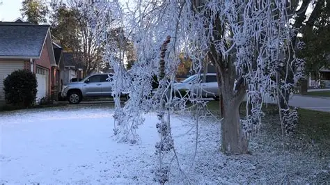
Meteorologists anticipate that Tallahassee will see isolated snowfall lasting only a few hours, primarily mid-to-late morning. Snow totals will be minor, with roughly 0.3 inches expected, significantly less than last year’s storm that prompted state emergency declarations.
Other northern Florida counties, including Leon, Wakulla, Gadsden, and Jefferson, may also see light snow flurries. Meanwhile, South Florida, including Miami, Fort Lauderdale, and West Palm Beach, will remain warm, with temperatures well above freezing.
Background: Comparing 2025 to 2026 Winter Events
Last year’s winter storm in the Florida Panhandle brought record-setting snow, sleet, and ice, forcing Gov. Ron DeSantis to issue a state of emergency for northern counties.
Legislative leaders, including House Speaker Daniel Perez and Senate President Ben Albritton, canceled meetings in Tallahassee due to hazardous conditions.
This year’s cold front is far less intense but serves as a reminder that even subtropical regions can experience rare winter precipitation when arctic air combines with moisture from the Gulf of Mexico.
Historical Perspective: Snow in South Florida
Snow in tropical South Florida is extremely rare. The only recorded snowfall occurred on Jan. 19, 1977, when Miami and Fort Lauderdale experienced light snow after a powerful cold front settled below freezing.
During that event:
- Homestead recorded a mix of snow and rain, the furthest south snowfall ever reported.
- The combination of cold air at the surface and moisture from the Gulf allowed snowflakes formed thousands of feet up to reach the ground.
- The event remains the only official snow report for Miami in modern history.
This rare precedent underscores that Florida snowfall is usually limited to the Panhandle and northern regions, with South Florida remaining nearly unaffected.
Timeline of Events for Sunday and Monday
- Early Sunday Morning: Arctic air pushes south, temperatures fall below freezing in the Panhandle.
- Mid-to-Late Morning: Isolated snow possible in Tallahassee, Leon County, Gadsden County, and surrounding areas.
- Late Morning to Early Afternoon: Snow ends; minor accumulation melts as daytime temperatures rise above freezing.
- Sunday Evening: Clear skies return, though the Panhandle remains cold with lows near 30°F.
- Monday: Cold air lingers, temperatures in the 30s to low 40s; mostly sunny skies expected.
- Tuesday: Warmer air returns; highs in the 50s and 60s for most of Florida.
Official Statements and Preparedness
Florida State Emergency officials note that this cold front does not require a state of emergency due to low accumulation.
Local weather offices advise residents in northern counties to:
- Monitor road conditions, particularly bridges and shaded areas
- Take caution if outdoors during the brief snow event
- Keep pets and vulnerable populations safe from cold exposure
Meteorologists emphasize that while snow accumulation will be minimal, slick spots may develop on roads during the brief snowfall period in the Panhandle.
Public Reaction
Residents in Tallahassee expressed curiosity and excitement about the possibility of snow. Social media posts highlighted the novelty of even a trace snowfall in northern Florida, with many sharing photos of frosty rooftops and streets.
Tourists visiting the Panhandle were advised to check local forecasts and plan outdoor activities around the short-lived snow period.
What Happens Next?
- Northern Florida will experience colder-than-average temperatures Sunday into Monday.
- Snowfall is expected to remain isolated, with no significant accumulations forecast.
- By Tuesday, warmer air returns, ending the brief cold snap and bringing highs to above-average levels.
- Residents in central and southern Florida can expect mild, typical winter conditions.
NEWS SUMMARY TABLE
| Key Detail | Information |
|---|---|
| Event | Cold front with isolated snow in Florida Panhandle |
| Location | Tallahassee, Leon County, Wakulla, Gadsden, Jefferson Counties; trace snow in central Georgia |
| Date | Sunday–Monday, Jan. 18–19 |
| Who Is Affected | Residents, commuters, tourists in northern Florida |
| Current Status | Snowfall expected mid-to-late morning Sunday; minor accumulation (~0.3 inches) |
| What Readers Should Know | Snow is rare; minimal accumulation; roads may be slick; South Florida unaffected; warmer weather returns Tuesday |
FAQ SECTION
1. Will it snow in Tallahassee this weekend?
Yes, isolated snow is possible mid-to-late Sunday morning, with totals around 0.3 inches.
2. Which Florida counties are most affected?
Leon, Wakulla, Gadsden, Jefferson, and nearby Panhandle counties may see light snow.
3. Will South Florida see snow?
No. Areas like Miami, Fort Lauderdale, and West Palm Beach will remain warm.
4. How does this compare to last year’s storm?
Last year brought record snow and ice, prompting emergency declarations. This year’s snowfall is minor and brief.
5. Has snow ever fallen in South Florida?
Yes, once on Jan. 19, 1977, when Miami and Fort Lauderdale experienced light snow due to a strong cold front.
6. How should residents prepare?
Monitor forecasts, use caution on potentially slick roads, and limit outdoor exposure during freezing temperatures.
7. When will temperatures return to normal?
Warmer air returns Tuesday, with highs in the 50s and 60s for much of Florida.
CONCLUSION
A rare winter cold front will bring isolated snowfall to northern Florida, including Tallahassee, Sunday morning. Accumulations are expected to be minimal, with trace amounts only, and South Florida will remain unaffected. While the Panhandle experiences a brief freeze, warmer air returns Tuesday, ending the cold snap. Residents and travelers should remain aware of temporary hazards on roads and plan accordingly during this short-lived weather event.